For this third post in our Port Davey – Bathurst Harbour series, we share with you the vastness of Bathurst Harbour. To really appreciate the extent and size of this basin and its inlets you have to climb those hills regardless of the soggy weather!

Overview Chart of Port Davey-Bathurst Harbour
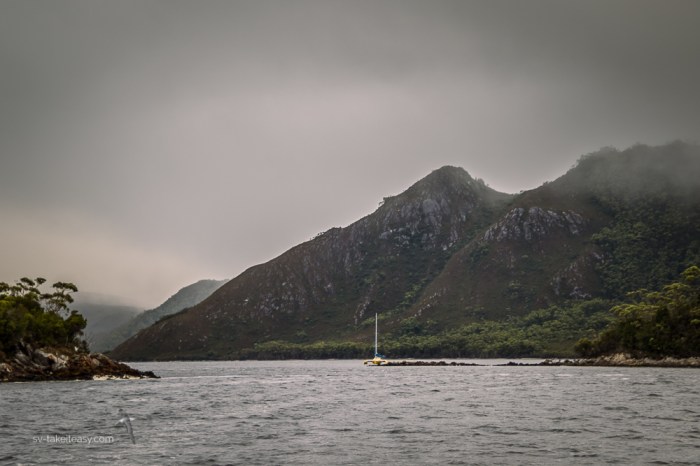
March-April were supposed to be good months to venture around the South West Wilderness of Tasmania. But we have had unseasonably sustained rainy and windy weather, the type of conditions you get at the start of winter! Despite the foul weather we have explored, often coming back from our bushwalks totally soaked and muddy but happy to have escaped cabin fever! And even in these dreary conditions, Bathurst Harbour is still awesome, and you feel insignificant in this vast landscape of stunning, moody moorlands, overlooked by rugged mountains.

Clayton’s Corner and Melaleuca Inlet – can you see Take It Easy?
Apart from the consistently bad weather here, we have also been amazed by the number of boats in this so called remote part of the world. We are all weather bound and congregating in a few broader anchorages, but yet it is a surprise and a little bit of a disappointment.
However, we are making the most of our stay in this stunning part of Tasmania. One of the highlights of our wanders has been seeing the critically endangered orange-bellied parrot at a bird hide in Melaleuca Inlet, where these rare birds are being helped to survive. Melaleuca and Clayton’s Corner where we have anchored, are the sites where two pioneer families cray-fished and mined tin in the 1930s. Both of these bases are used as huts for visiting yachties and tourists. And a new spot we discovered that reserves a serene and peaceful anchorage to shallow draft vessels was Moulters Inlet, which we shared with another multihull.
Coming up to Moulters Inlet
Once again we share with you a gallery of moody shots taken in between downpours. For our next post, we will let you escape out of Port Davey and take you past the three capes guarding the Southern coast of Tasmania. Life jackets on for that part of the trip!


I can see clearly the kind of weather you had to endure while hiking on those high moors. I’m happy that you had the opportunity to photograph some birds. How long are you staying in that location?
Yesterday I was looking for Tasmania in Google Earth and found out how large this island is, Is as large as New Zealand! However it’s a you said, almost empty of civilization. Good though! Take care Chris. 🙂
Hi HJ – yes this part of Tasmania is truly wild! We have now left the SW wilderness and come to Hobart, the capital. There is some more nasty weather on the way so we will stay here for a week then start heading North.
It all looks incredible and spectacular. What an adventure.
Yes and it is breathtaking even in rainy conditions. But we are pleased to be in Hobart now for a bit of pampering!
And long showers I hope?
You bet!
More stunning photography! Though I’m surprised that you didn’t have every anchorage to yourself. What a great place to explore, though. Do the tides run strong coming in and out of Bathurst Harbor? It looks like a large body of water accessed through a narrow strait!
Hi Ellen – thanks for the feedback. Yes only one or two of the anchorages were empty which was a shock to us. No tide to really talk about… half a meter if that!
Interesting! It looks on the chart like it would be ripping through there, so that’s great 🙂 Looking forward to your next post!
I am sooo jealous of having seen the parrot. Again great moody shots of that fantastic wilderness. Have fun in Hobart. 🐬🐾
We were incredibly lucky, Sue. So stunning! Last time we were here we did not see the parrots.
You are so lucky to see the OBP. We thought we’d seen one in the Tarkine a few years ago but it turned out to be a Blue Winged. Great photos as usual. In Hobart we can recommend the food walking tour.
Hi Trish – yes very lucky. They are stunning and so few of them!
Did aboriginals used to live around Bathurst harbor? Any known archeological sites?
Hi Craig. Yes aboriginal people occupied the Tasmanian Wilderness World Heritage area for at least 35000 years. Ice age sites have been discovered showing they lived under alpine conditions. Changes in climate drove them to abandon sites as wet forest encroached and prey species disappeared. The area was reoccupied 4000 years ago. Hundreds of middens containing the food remains of shellfish, birds, land and marine mammals have been found. Nowadays there is an aboriginal site recreation and a walk at Melaleuca called the Needwonnee Walk after the tribe whose homelands extended from Port Davey to New River Lagoon, including the Melaleuca Inlet.