Big milestone this week: we made it into the Gippsland Lakes with a stop at wild Gabo Island on the way. Since then we have been rushing around to catch up with local friends, pick up our guest Trevor, and get the boat ready to go again!
Here is our track:

Bittangabee Bay to Gabo Island
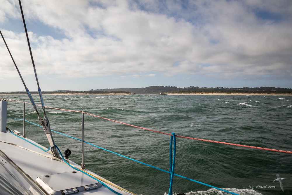
Typically when going ‘around the corner’, yachts go from Eden to the Gippsland Lakes in one long 125nm overnight sail. As is our preference, we generally look for opportunities to break the passage and day sail to stop at seldom visited spots.
With light northeasterlies then southeasterlies for two days, we had perfect conditions to break the journey. We left Bittangabee at dawn in very overcast conditions, passed nearby Green Cape, then Cape Howe marking the border between NSW and Victoria. We were aiming for Gabo Island, only 26nm away, with the intention of spending the day there.

We saw several albatrosses, lots of shearwaters and a few seals lulling about, the unmistakable sign we are now in Southern waters.

Located at the very southeastern corner of Australia where two massive bodies of water – the Tasman Sea and Bass Strait – meet, Gabo Island is an iconic place to visit. It is a windswept outpost commonly referred to in Victorian weather forecasts issued by the Australian Bureau of Meteorology.
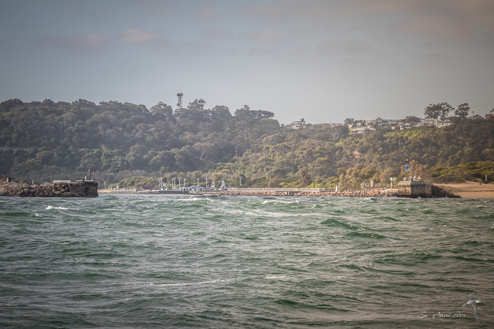
The island is separated from the mainland by a 500-metre-wide (1⁄4-nautical-mile) but very shallow channel – only for the brave or foolish! We went right around Gabo and anchored on the western side of the island at Santa Barbara Bay.

It is well protected from the NE wind and there is minimal swell, particularly on a calm day. Although there is a jetty, only small vessels weighing less than 4.5 tons can tie up there. We anchored not far from it in 10m of water.

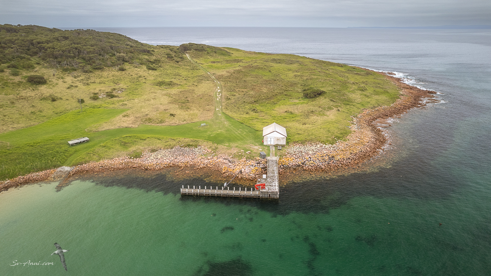
We used the kayak to get ashore. It is an easy 5km return walk from the jetty to the Lighthouse on a well-maintained track.

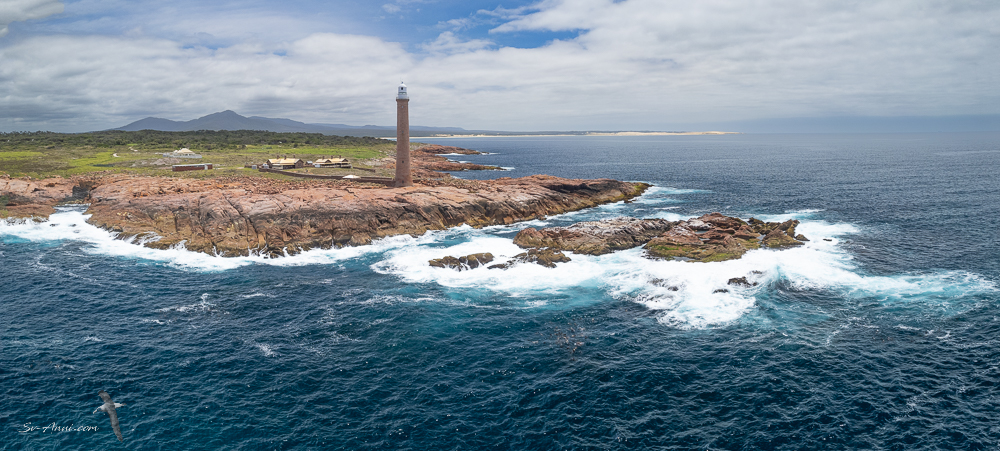
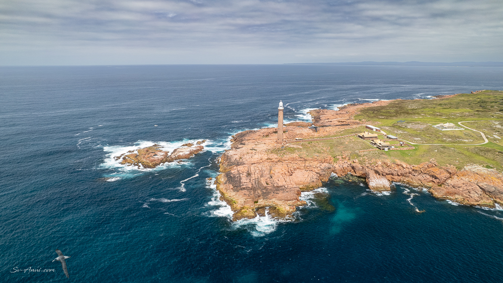
The lighthouse was constructed from 1858 to 1862 using the distinctive pink granite found on the island and is the only operating island lighthouse in Victoria. You see the granite slabs everywhere and there are two quarries.


The aerial shots below show how unforgiving the coast is. The first image is looking east towards Cape Howe. The second looks west. Many ships have been wrecked along this coastline.
The island is home to one of the world’s largest colony of little penguins, another sign we are in Southern waters. We could hear them coming ashore at night, and during our walk we saw numerous tags in the grassy slopes marking their nesting sites.
Gabo Island to the Gippsland Lakes
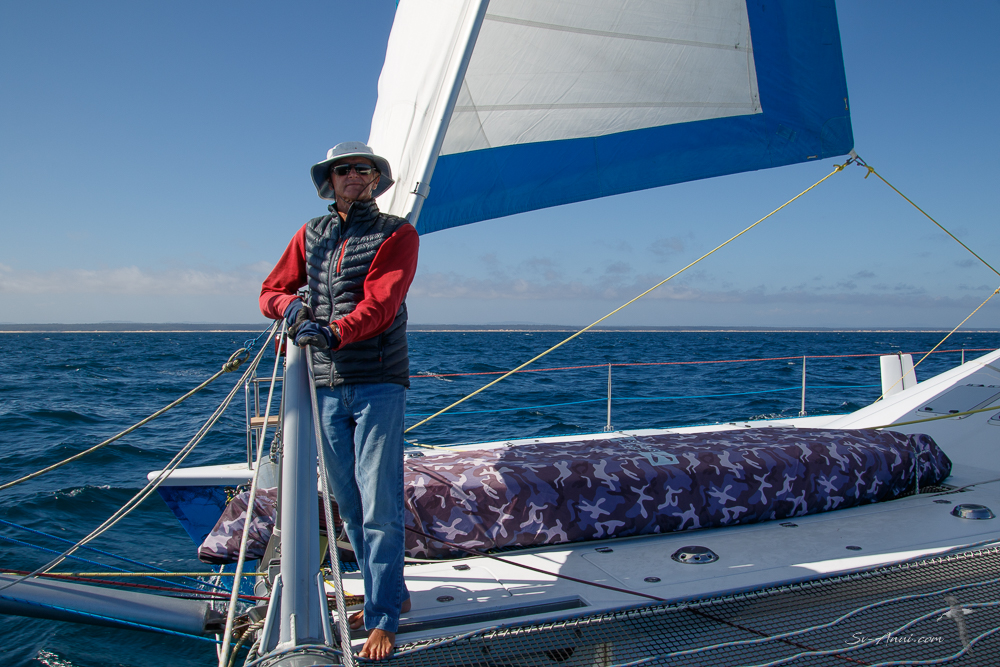
It was another dawn departure on Sunday to ensure we would reach our destination, 98nm away, with an incoming tide to cross the bar and in daylight. Anui did a great impersonation of a motorboat for a while, with the wind on our nose and very overcast conditions to start with. So while the engines were going, we made water underway. Eventually, after 6 hours of tedious motoring, the wind switched to the SE as forecast, we raised the sails and had a gorgeous run for the next 7 hours, accompanied by yellow nose Albatrosses. The photographer admits to feeling very rusty on the old panning technique to capture these majestic creatures in flight! Dozens of blurry images taken, a few clear enough to include here. The good thing: plenty more practice to come!


As well as the albatrosses, the passage was punctuated by various capes: Little Rame Head, Rame Head, Point Hicks, Cape Conran… This is Point Hicks, under threatening skies.

Of course, being in southern waters also means you have to ‘dress up’. Shorts and t-shirt have given way to jeans, jumper and fluffy jacket. It’s chilly down here, but still no sea boots, so not that bad!
And then after a 13-hour passage, we were in! That entrance made us feel a bit tense, even though we have crossed it many times.
The tide continues to ebb for two to three hours after the official low water. We arrived earlier than planned and entered at mid tide rising, but the water was still flowing out strongly. However with light wind and no swell we powered our way in. Rather than going into to Lakes Entrance proper, we followed the Reeves Channel, picked up a public mooring a few miles down and it was time for a shower, a meal and a rest!
Inside the Gippsland Lakes
After feeling chilly at sea, the next day was a 40oC day – who needs QLD? We moved to Paynesville, a 3 hour hop further west along the Lakes.
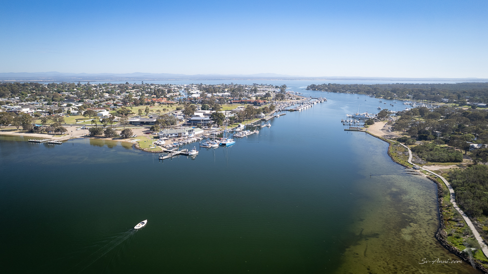
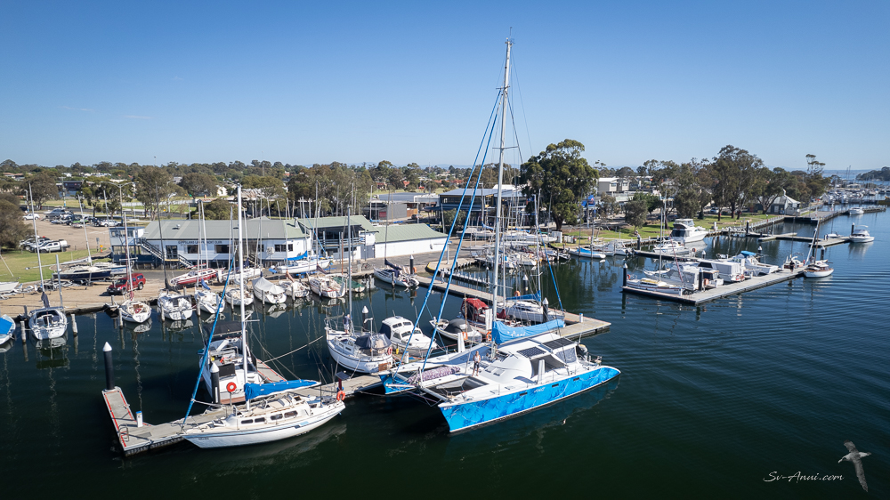
It used to be our home port, so we had a busy few days catching up with friends, making up for nearly three years of absence as best we could. Our guest Trevor joined us, we did our chores and prepped the boat for the next passage.
As you can imagine, we were yet again checking the weather obsessively. We wanted to minimise the risk of sea sickness for Trevor’s first ever sail across Bass Strait! We think it will be about our 25th crossing (we don’t count the skirting along the Victorian coast). So we decided to wait an extra day for the ocean to settle after the strong southwest.
We could have stayed at the jetty in town, but instead thought it would be nicer to escape for an afternoon and a night to the Bunga Arm, picking up a public mooring next to Steamer Landing. The Bunga Arm is a 250-metre wide sand barrier separating the tranquil waters of the Gippsland Lakes from the rough ocean swells of Bass Strait. Beach walk, peaceful floating about, nobody else around… It was a good move and it is always nice to discover familiar places from the air. By the way, the colours of the ocean are naturally vibrant – unedited.


We returned to Paynesville on Thursday morning for the final re-provisioning, caught up with James, our old shipwright, then it was time to head back towards the Entrance.
And as we hoped, we exited the Gippsland Lakes at dawn this Friday morning and are on our way to Deal Island, where we will spend Christmas. Our Tasmanian adventure has started!

Merry Christmas to all. We hope that like us you are spending the festive season doing something you love with people you love.


What a delight to wake up to this! Obviously to find out about your pre-Yule progress . . .but for me also! Being somewhat of a meteorology ‘freak’ Gabo Island has always played a part in the nightly news – now to be there! And, as you may have seen from my reposts, a couple of dear Dutch friends are on a similar around the Coast journey from yours but on land . . . and Lakes Entrance very much came into play last week. Oh, and they have just camped on Wilson Promontory a day or so back! Am so looking forwards to a Christmas journey from Deal Island . . . and this week’s photos methinks will be reposted. . . Oh, do have a very, very happy beginning to the festive season all four of you . . . miaow, miaow, miaow Bengie ?!!
Hello Eha, Gabo was a delight, so were The Lakes, but nothing can ever beat this dawn departure! We nearly had to turn back when the autopilot did not want to work, all because of a loose screw! But it is sorted and we are on our way to Deal Island! Merry Christmas and hugs from us. Bengie is out sunning herself and sends you a tail cuddle. 🐈
Safe passage and enjoy you Christmas at Deal. Top Spot
Thanks Graham, just anchored there at 6.00pm. Mission accomplished! Merry Christmas to you too.
A beautiful place to see, I envy your travels! Be safe out there, guys.
Thanks John, we are indeed fortunate to visit stunning places!
Hi Chris and Wade, Thanks for your update, Doug and I always enjoy reading. Photos are superb too. Wishing you more safe travels and a very happy Christmas. May 2025 be a great year for you.
Hi Jeanette & Doug, lovely to get your comment. Merry Christmas and all the best for 2025. Hope to share an anchorage somewhere north!
Lots of good wishes for the Festive Season. I loved Deal Island when finally got there earlier this year… what a wonderful stop! For some reason I have the fantastical image of gift wrapped boxes overflowing out of wallaby pouches! Love to you all!
Hi Trish, yes the wallabies are numerous here at Deal! We are wrapped we have made it and will be spending Christmas hiding in Winter Cove!
Great spot!
Love those aerial shots of Bunga! Lots of memories there. Wishing you a safe passage to Tassie & a Merry Christmas to you both!
The Bunga Arm was great fun to revisit and it is always special to rediscover familiar spots from the air. Merry Christmas to you Amanda and Neville! We have made it to the first of our Tassie hops. So pleased we had a great sail over to Deal.
Merry Christmas! Hope you have a wonderful holiday season and happy sailing.
The aerial shots are great to see the coast. The coast does look unforgiving but the lighthouse stands so brave and mighty there.
Yes, the Gabo Lighthouse is spectacular and the Gippsland Lakes gorgeous and protected. Merry Christmas Esther to you and your family.
Lighthouses and their keepers must have tales to tell! Thank you for the holiday wishes. Wishing you both a healthy and happy one too with smooth sailing. 😎
Merry Christmas guys! And a joyous new year of sailing adventures!
Thanks Elgar & Claire, all the best to you too.
Magic photos as always!
Merry Christmas to all aboard Anui and I hope the weather is beautiful for you at Deal Island.
xxx
Roobi Crew
Merry Christmas Roobi! Having a nice few days at chilly but sunny Deal Island.
❤️
A late question born out of ignorance! Does the Sydney > Hobart fleet sail past you or far further east? Oh . . . and it’s cool here this morning . . . hope ‘winter woollies’ are not needed on Deal !
Hi Eha – fair question- the Sydney to Hobart fleet passes east of Flinders Island so well offshore of us. We are in northern Bass Strait. And yes the winter woolies and Ugg boots are out at Deal Island… very windy and exposed here!
*huge smile* Thanks for the geography lesson – just looked at your absolutely marvelous map I’ll keep again . . . and the routing makes sense!! Be well even if colder than you are 11 months of the year . . . love . . .
Great trip down and you are now in spitting distance of Tassie.
Are you going to the Furneaux Group?
Hi Mick, yes we are spending a couple of weeks revisiting old favourites as the weather allows before starting our lap of Tassie.