Hurray! Plan B of our Easter Cruise is back in action! Thursday being a light SE day, we left Refuge Cove and headed to the Western side of Wilson’s Promontory with beautiful, wild Oberon Bay as our destination. Rounding South East Point is always special as it houses the lighthouse for the southernmost point of mainland Australia and then when the conditions are calm you can have fun exploring the numerous islets off the West coast. There is Rodondo which marks the centre of the shipping lanes around the Prom. As the name suggests it is a roundish, cone-shaped island which often generates its own cloud; no landing there with 200m high cliffs at its base! Then there is the Anser Group of 4 islands and the Anderson Islets frequented by rowdy seals. Beware of the unbelievably bad smell as you get close in certain wind directions, but those beasts are fun to watch as they slither down the rock slabs right into the water to come and check us out.
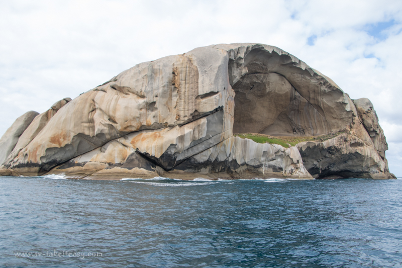
Cleft Island, looking very much like a skull!
By far the most distinctive isle of the Anser group is Cleft Island, also known locally as Skull Rock. This is a truly impressive isle with sheer cliffs standing vertically on 2/3 of its perimeter, but with a huge cavern on one side with a grassy floor. We wished we could climb up in there, but again no possible landing with tall vertical cliffs to the base of the cave! The cavern is said to measure 130m wide, 60m tall and 60m deep. Just as a comparison, and remember I am French, you could fit 6 Arcs de Triomphe (3 side by side by two deep) and you would still have some room to spare! From one particular angle as you sail away from the island, it does looks like a skull, complete with a big cranium, an eye socket (the cave) and the bridge of a nose. It is such a wonder of nature and the tremendous power of wind, rain and sea over millenniums.
With light sunny conditions we continued our exploration and headed for the Glennies, another group of 4 isles forming a barrier 5 miles west of the coast. We had heard there is an anchorage on Great Glennie, the largest isle of the group and the spot is marked on the chart as “Good Landing”. It is not for the faint hearted though as it is a deep cove with no swinging room. So you need to back the boat into it, throw the pick in and tie yourself back to the rocky shore, or if you are game, to some iron stakes in two rocks on one side of the cove. We had a good look… a great project for another visit. Once ashore it looks like an interesting spot to explore afoot: there were lots of birds including sea eagles, Cape Barren geese as well as the obligatory cormorants, gulls and terns.

Oberon Bay
That bit of the reconnaissance done, we were off to Oberon Bay. This is a broad bay with towering hills, dolmen like granite torrs along the ridge lines, a broad sandy beach and teal water. Take It Easy looks miniscule in this awe inspiring scenery. There is only one catch with this beach: you anchor a long way out as it shelves very slowly and dries out for miles at low tide… Oh, and the other catch: landing the dinghy in the surf. It was a full body dunking for Sue, who has not yet perfected the “quick hop out of the dinghy and run like hell to escape the next wave”! You did want a shower, Sue… You got a bath instead! We did say “hop out” not “roll out of Peasy”. We spent two nights at Oberon and explored a neighbouring sandy beach by dinghy, but were not game to go ashore with the feathering waves rolling in!
Saturday saw us up anchor early with a SW change, just what we needed to get back around the Prom. We motored early on and enjoyed a pink sunrise then a lovely sail as the wind picked up. The light was beautiful over the granite islands. We also were mesmerised by thousands of shearwaters headed northwards and majestic albatrosses enjoying the windy conditions. Our overnight anchorage was Sealers Cove, just north of Refuge Cove, another broad beach, rarely frequented by yachts, thus so nice as an alternative to crowded Refuge Cove. We got there at low tide by 9am just in time for a breakfast of bacon and eggs! Then it was time to go fossicking ashore, in search of shark egg cases! We found plenty to add to ours and Sue’s collection! For those interested, back in September last year we published a post on sharks and their egg cases. Click on the link to revisit.
Sunday being our last day, it is back to our Port Albert mooring, via the Seal Island Group to see… you guessed it… more smelly Australian Fur Seals. We do like those boisterous beasts and will probably do a feature post on them soon. It is a great sail there and back to port under Big Red, our spinnaker – a nice way to end the trip.
Unfortunately our Easter 2015 Cruise has come to an end. Although we had fickle weather, we managed to do a lot of exploring and enjoyed our adventure. Here is a gallery of photos we took in the last few days. As usual, click on the first image to display in full screen slide show.


I’m so glad the trip came good at the end and wasn’t totally a bad. You got some great photos, I love those rock formations, they are incredible.
Hi Leanne – yes we ended up doing quite a bit of exploring. The Prom is always interesting with the granite boulders with orange lichen. Driving home now!
Cleft Island is a really cool rock formation! Great shots with the pink clouds.
Thanks guys, yes Cleft is so imposing and really unusual!
I love it when Plan B is nothing short of being as fantastic as Plan A… and great pics, as usual! Thanks! 😉
Hi Hubert, yea it all worked out in the end😊
beautiful and I wish you could get into cleft island!
So do we Cybele! We have been right up to it with the boat, but the water is very deep all around and the cliffs to the base of the cavern are really high and vertical. Apparently the only people who have got onto it where a film crew doing a program on amazing Australian places and were winched down by helicopter!
Thanks for the awesome photos and stories. Chris, I reckon you could throw Wade overboard with a wetsuit and surfboard close to cleft Island and then he could paddle in with a go-pro, maybe find a way up the cliff and get some land pics of inside the cave.
Only one problem: he needs a rock climbing rack on the surf board and someone to belay him as the vertical wall to the base of the cavern is much higher than it appears! But yes what a challenge! It is an awesome place!
Pingback: The Australian Island That Looks Like Skull | Ready2Reach